Three Rivers
Hudson~Mohawk~Schoharie
History From America's Most Famous Valleys
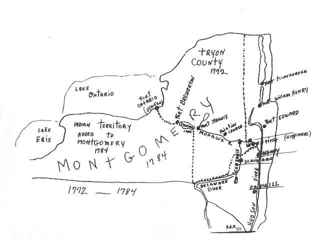
Original Montgomery County
The dotted line = size of country in 1772. In 1784, Montgomery County covered all the land from the Albany County line west to Buffalo and from the Pennsylvania line to Canada.
Written in 1980 by Anita Smith while she was Montgomery County Historian. Used with permission.
TRYON COUNTRY, as Montgomery County was originally known, was set off from Albany County in 1772 on the petition of Sir William Johnson and named Tryon in honor of his friend, the Colonial Governor William Tryon. Johnstown was set up as the County seat.
In 1784, after the close of the Revolutionary War, the name of the county was changed to Montgomery in honor of General Richard Montgomery. The Indian territory, or all the land south of Oneida Lake and west of Utica to the present city of Buffalo, was named Whitestown, in honor of early pioneer Hugh White, and was added to Montgomery County.
The first road improvement through Montgomery County came in building of what was known as "The King's Highway" on the north side of the Mohawk River. It was little more than a military route. Work was begun in 1800 on an improvement that was known as the "Mohawk Turnpike". Operation of the main route through the valley was a big contribution to development of the western part of New York and western states.
Opening of the Erie Canal in 1825 gave big advantages to Montgomery County communities on the south side of the Mohawk River where new hamlets grew overnight and early-established villages enjoyed booming business. Hay and farm products were shipped to New York and packets carried both local and cross-state passengers in leisurely comfort as judged by standards of the time. "Clinton's Ditch" the scoffers called it, but the waterway drew so much business that it was being enlarged before 1840.
The "DeWitt Clinton" that pulled the first train through Montgomery County in 1836 attracted a lot of attention on its first day out. Like the Canal opened a decade earlier on the south side, the railroad did much for the communities on the north side of the Mohawk. With one exception, all communities of Montgomery County just "grew naturally" as more and more people moved in. The only planned community is Fonda, brain child of a group of developers who thought that the coming of the Schenectady and Utica Railroad in 1826 had sounded the death knell of Johnstown as a county seat. It was, they said, too far away from the railroad, from the Erie Canal and from the main line of travel, and so they built other buildings.
Determining the pattern of early settlements in Montgomery County were the streams of various sizes that flowed into the Mohawk from the valley hillsides. Water was turning mill wheels along the rivers and creeks as industry struggled in infancy in the early 1800's. Grist mills, lumber mills, and similar production centers that served the countryside attracted other businesses and little hamlets grew as water wheels creaked.
Bridge building was a gambling venture for the companies organized during the early part of the 19th Century. One of the discouraging examples was the Fonda-Fultonville crossing opened in 1811 and carried down stream within the year. Bridge builders persisted, however, and improved know-how produced more enduring structures. These paid off so well that bitter litigation delayed construction of the first toll-free bridge at Fort Plain in 1857. That departure established a new pattern and the fight for toll-free bridges continued.
By 1840, Montgomery County residents were discovering that there were other ways to make a living than by farming. The age of machinery had arrived and the early grist mills and saw mills were being replaced by factories powered by water wheels. Groups of workers were being organized to turn out farm machinery, tools, furniture, wagons, wearing apparel and countless other products.
Montgomery County's awareness of the Civil War came to a high point in August of 1862 when the hills above Fonda were bustling with activity. Here was Camp Mohawk induction center of the 115th Regiment that was preparing to leave for the battlegrounds of the south. Less than 200 of the original regiment of 1,049 that included 421 from Montgomery County remained to be mustered out in June of 1865.
The ornate grill work on the Fultonville Freight Station is among fast-disappearing reminders of the Mohawk Valley's second railroad, officially known when it was opened in 1883 as the New York, West Shore and Buffalo Railroad. Montgomery County communities on the south side of the river held high hopes when construction was started around the Noses in 1879 but troubles began early. These included a head-on collision on the first day of operation. Opposition of the New York Central forced down the competitive fares to one cent a mile, also freight rates. The villages protested disfigurement, and financial troubles plagued the backers. The West Shore was taken over by the Central in 1886.
Prior to 1873, all Montgomery County residents who did not own or who were unable to hire a horse and carriage were community walkers. In that year, Amsterdamians saw their first horse cars. This same service was extended between Fonda and Fultonville two years later. By 1890, the electric car had arrived to replace the horsepower carriers and local travel was speeded considerably. In another decade, cities were being connected by electric railroads and by 1903 it was possible to ride by trolley from Gloversville to Fonda, to Amsterdam and to Schenectady. Transportation changers came rapidly, however, and in another quarter century the trolleys were being replaced by buses.
The Mohawk River in 1900 was un-navailable as it was when possibilities of inland waterway transportation attracted attention of George Washington in 1783. A statewide referendum held in 1903 indicated lessened opposition of expenditure of $101 million. Approval came in realization that the Erie Canal had outlived its usefulness. Construction of the first river lock in the county started at Cranesville in October of 1906, and the Barge Canal was opened for navigation in May of 1918. High hopes of the Barge Canal in industrial development were not realized in the Montgomery County area. Traffic in pleasure craft also failed to attract local attention with the exception of the St. Johnsville Marina.
When the Thruway was first talked about, plans called for Montgomery County construction on the north side of the Mohawk River. By the time the Legislature, in 1944, authorized the start of construction the cross-state highway ideas had changed to the south side. Moving the river to make more room around the Little Nose Mountain was begun in 1948 and the first main contract was started at Amsterdam in 1952. Although the superhighway removed sections of villages on the south side of the river, the overall result was extensive commercial developments east and west of the principal communities. The Thruway, marking another transportation era, had found Montgomery County in a position to grow and benefit.
Copyright © 1998, -- 2003. Berry Enterprises. All rights reserved. All items on the site are copyrighted. While we welcome you to use the information provided on this web site by copying it, or downloading it; this information is copyrighted and not to be reproduced for distribution, sale, or profit.