Three Rivers
Hudson~Mohawk~Schoharie
History From America's Most Famous Valleys
The
Mohawk Valley
Its
Legends and its History
by
Max Reid
New York and London G. P. Putman's Sons
The Knickerbocker Press, 1901
with illustrations from photographs by J. Arthur Maney
Chapter XIX Old Indian Names and Sites--The Legend of Little Falls
There is more or less speculation about the origin of the word Caughnawaga, the popular impression being that it was the name of a tribe of Indians that were located near the present site of Fonda. This cannot be, as there never was a tribe of Indians of that name, but it may have been a corruption of two words, Gandawague, the name of an Indian village of the time of Isaac Jogues, and probably located near Kline, and Ca-han-i-a-ga, the distinctive name of the Mohawks. (Of course you are aware that the word "Mohawk" is not Indian at all, because there were libials-b, p, m-in the Mohawk language; but it is undoubtedly what was called "Mohawk Dutch.")
There is another definition of the word Caughnawage, which seems to me to be the correct one. Between 1667 and 1669, the French Jesuit Fathers Pierron, Bruyas, and Fremin were successful in converting a number of the Iroquois to Christianity. Father J. Wynne of the order of Jesuits of New York City in a recent letter says: "You will notice that it was the policy of the fathers to withdraw the Christian Indians from the Indians still unconverted, all along the valley, from the lower Mohawk castle as far as the Onondaga."
The "Praying Indians," as they were called, were located near the Lachine Rapids on the St. Lawrence and the village named LaPrairie on the St. Lawrence and the village named LaPrairie by the French and Caughnawaga ("at the Rapids") by the Indians; and although the settlement was composed of Indians from the Canadian tribes and the tribes of the Iroquois Confederacy, among whom was the great Mohawk chief, Krin, they were always called Caughnawagas, or Praying Indians. At the burning of Schenectady there were sixteen Algonquins, and one hundred and fourteen Frenchmen, and eighty Caughnawagas or Praying Indians led by Krin, the Mohawk Chief. It will be seen that although the name may mean and probably does mean "at the Rapids," is does not refer to rapids in the Mohawk, but to the site on the St. Lawrence at the Lachine Rapids. The Dutch named their early settlement near Fonda Caughnawaga, thereby transferring a word that belonged to the St. Lawrence River to the Mohawk Valley. The Dutch settlement was located at the eastern end of the present site of the village of Fonda, the old Caughnawaga church erected in 1763 and demolished in 1868 probably being the center of the old settlement. Investigations by archaeologists of the Mohawk Valley have brought to light the site of an Indian village, which is also called Caughnawaga or Gan-da-wa-gua, situated on the sand flats west of the village of Fonda. A desire to see the old Indian site was the object of a recent visit to Fonda by the writer.
Inquiry of many persons young and old failed to elicit the desired information as to its locality, and an accidental meeting with the Rev. Washington Frothingham seemed providential, as he possessed the requisite knowledge of its location and kindly imparted the same. Following his direction I visited the sand flat where it is said to have been situated. Accustomed to flats of the Mohawk Valley which lay along the river and are frequently covered with water in spring and during heavy rainstorms, I was somewhat surprised to find the sand flats on what is called the four hundred feet plateau. I enjoyed the tramp to this elevated plateau, and was charmed with its level, fertile fields and its fringe of forest trees that partially obstructs the view to the east and to the north, while to the west and south the landscape reminded me of the words of Byron's Dream--"A gentle hill green and of mild declivity, the last as it were the cape of a long ridge of such, save that there was no sea to lave its base, but a most living landscape, and the wave of woods and fields of grain, and the abodes of men scattered at intervals, and wreathing smoke arising from such rustic roofs"--and in the distance the glistering, shimmering Mohawk.
Although unsuccessful in my search for the exact location of the site of the ancient village, I felt well repaid for my walk, notwithstanding the dusty road and excessive heat that brought my blood nearly to the boiling point. At a subsequent date, having informed myself of the exact site, from a map drawn by the Rev. C. A. Walworth,and published in Miss Walworth's Lily of the Mohawks, I continued my search in company with Prof. J. A. Maney.
Starting from the railroad depot our attention was attracted to the old Fonda Hotel, its facade of Ionic columns suggesting the idea of a Grecian temple. It is quite an ambitious structure, and must have presented a very impressive appearance at the time of its construction, in 1835, from its isolation and the poverty of its surroundings. A suggestion of the same style of architecture is also seen in the old court house, south of the New York Central Railroad.
Our route to Caughnawaga and Tekakwitha spring led us up Main Street to the Cayadutta Creek, which we followed along its eastern bank until we came to a white bridge spanning the creek. The bridge seems to have been constructed for private use as the road leading from it ended in a farmyard. As we were nearing our destination and desiring more definite information, we accosted a sturdy young man we met as follows: "Excuse me, sir, do you reside near her?" "Yes, sir." "Have you loved here long?" "About seven or eight years." "Do you know where the site of the old Indian village, Caughnawaga, is located?" "No, sir." The Professor smiled as we passed on, remarking that we were having our usual success. In the farmyard we met a man whose slow step, bent form, and gray hair seemed to indicate a septuagenarian. After the usual preliminary greeting I inquired: "Have you lived here long?" "Over sixty years." "Did you ever hear of a spring called Tekakwitha spring?" "No." "Do you know where the site of the old Indian village, Caughnawaga, is?" "That is down that way," pointing to the east, "but they say that there are some Indian graves up on the sand flats." "Can you tell us where?" "Up on the top of the hill, but I don't know just where."
The Professor again smiled and we again passed on, remarking that we would have to trust to the map. Rain drops were beginning to fall, but not daunted in the least we followed the track of the F. J. & G. R. R. along the high ground on the west for about a quarter of a mile, until we came to a point where the Sand Flat Hill recedes from the railroad in the form of a half circle, forming a level swampy field partly covered with brush and berry bushes. Following an indistinct path through this tangled mass, which led us in an erratic manner up and down the slope and through the swamp, we came at last to a wooded ravine at the head of the circle. A barbed wire fence was safely passed and we found ourselves in a small grove, and, about halfway up the hill, came upon Tekakwitha spring. With a great expansion of imagination we pictured the young Indian maiden in the scanty dress of Indian childhood, picking her way down the steep woodland path from the plateau above, with a rude earthen jar to be filled at the spring below. Perhaps other children of both sexes were following her, while at the spring crouches a painted warrior drinking in a primitive way of its cool water. Nearby stands a dirty, unkempt squaw, cooling her feet in the stream that ripples down the hillside on its way to the Cayadutta Creek, while all around, the earth has been trodden bare by the coming and going of many feet from the village on the flat above,and broken branches and dead leaves choke the murmur of the waters.
Today the stream is marked by the impress of the hoofs of the kine of the valley below, and scattered about are broken pieces of decaying fence boards, an old tine pail, a bit of red tile, and two narrow planks doing duty as a bridge near the spring. The spring itself issues from under the roots of a white birch tree, whose leafy branches bend over the spring as if to guard it form the rays of the sun. The gnarled and tangled roots of the parent tree remind one of the tentacles of a huge octopus, as they stretch out over and into the black depth of the spring itself. Nature, with the aid of art, would make this little vale a beautiful spot. The Professor, who took a snapshot of the spring and its surroundings, and who has a reputation of producing gems of beauty from the most incongruous elements, succeeded in making a very fine photograph of this secluded spot.
We were nearing the end of our search for the Indian village, and climbing the steep path out of the ravine, we reached the sand flat and the field wherein the site of Caughnawaga is said to be. Diligent search failed to find any evidence of the old village, as the woodman's axe and the ploughshare have long ago obliterated all trace of palisade and Indian sepulture. Previous search and examination, together with the finding of evidences of Indian occupation, have established the fact, however, that this spot was the site of old Caughnawaga.
Kateri Tekakwitha was an Indian maiden born at Gandawaga (Caughnawaga) in 1656. Her mother was a Huron captive and her father a Mohawk chief. At an early age she embraced Christianity, and in 1675 was baptized by the Jesuit Father de Laberville. Shortly after, she fled to Canada to escape the persecution of the Mohawks, on account of her religion. Her route is said to have been along the Chuctanunda Creek at Amsterdam,and the destination Caughnawaga, at the Lachine Rapids, on the St. Lawrence River, where she arrived in the autumn of 1877. She died April 17, 1690, at the age of twenty-four.
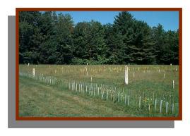 Recent
photo of site of Indian Village outside Fonda.
Recent
photo of site of Indian Village outside Fonda.
In Miss Walworth's Lily of the Mohawks, the story of her life is told.
A few months ago I was riding in a drawing room car on the New York Central Railroad through the Mohawk Valley. In the same car was a small party of gentlemen and ladies, and it was apparent from their conversation and personal appearance that they were well-to-do, educated people, from one of our Western States, making their first trip through the valley of the Mohawk. It was very interesting to not their enthusiasm over the rocks and hills, after a lifelong residence on the flat lands of their Western prairies, as they would call their companions' attention to a picturesque group of rock or the wooded slope of some slight elevation. Unconsciously my eyes would follow the direction of their gaze, and would become aware of charming bits of scenery that through familiarity with the banks of the Mohawk I had passed many times without comprehension.
From being interested in their evident enjoyment of the scenes they were so swiftly passing through, I became interested in the scenery itself, and discovered many beauties in the valley of my lifelong home that I had overlooked or had become so familiar with that they were, in a measure, rocks, and hills, and streamlets, and nothing more. Since that day I have looked upon the scenery of the valley with the eye of an enthusiast, and have found beauty in every bend of the river and in every ripple of its riffs and shallows.
Here and there throughout the valley numerous tributaries flow into the river, some of them being large, permanent streams, other mere rivulets, magnified into torrents at every considerable rainstorm.
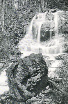 |
Adriutha Falls, Cranesville |
In many of the ravines or gorges through which these smaller streams flow are hidden charming bits of scenery, some of which might be dignified by the word "sublime." I have in mind the ravine through which Lewis Creek runs, which I visited with Charles Newman of Cranesville. As before stated, this creek is the eastern boundary of the land which was purchased by Lewis Groot in 1715 (who was one of the first purchasers of land in the town of Amsterdam), and named Adriutha, and known as Cranesville.
There are many objects of interest in this ravine, one of which is a very large spring that is situated at the base of the hill about three hundred feet from the turnpike.
The volume of water issuing from this spring was sufficient to furnish the requisite power for the primitive mill erected by Groot in 1730, on the site of the old building now known as Swart's mill. At the present time there are the ruins of two old milldams between the mill and the spring, the woodwork of the structure having decayed and almost entirely disappeared. The dam nearest the spring is the smaller of the two and seems to have received the water from the spring alone. The sides and front of the dam are earth embankments, but the face or pour is reinforced by a dry wall of flat stones. This stone front is further reinforced by stone buttresses on each side in the shape of a quarter-circle, while in the face of the front wall is a square opening or gate with rotten wood facings, evidently used to discharge the water into the lower dam. The lower dam is constructed of earth and stone, in the same manner as the upper one,but without the stone buttresses, the two together being capable of storing quite a respectable quantity of water. The gray or rather almost black, stone walls are moss-grown and in various other ways give evidence of their age, which is "nigh onto" one hundred and seventy years.
The spring itself will warrant more than a passing notice. Care was taken ages ago to wall it up on three sides, making an enclosure about six feet square, in the center of which the water boils as though forced from below, in a quantity that would fill and eight or ten inch pipe, and from the situation of the dams it would appear as though the water from the creek, which is some distance away, was excluded from the dams. Probably because the flow of water in the stream was small except in storms, when it became a torrent.
Penetrating the ravine a little farther, over a rugged path, we find that Lewis Creek is made up of two streams, one from the east and another from a northerly direction, the acclivity of the banks of both ravines being almost insurmountable. Entering the bed of the stream which flows from the northerly direction we become aware of an obstacle in our path that it will be impossible to overcome,which is the sheer precipice, of perhaps fifty feet in height, of Adriutha Falls. I would say that this name, Adruitha, is applied to the falls probably for the first time, as it is usually spoken of by the homely name of Buttermilks Falls, although the application is not evident.
All this locality between Lewis Creek and Eva's-kill was called Adirutha or Adriuche, and this name is mentioned in the transfer of this parcel of land, and flats and woodland directly opposite at Kline, the supposed site of On-e-ka-gone-ka, to Hendrick Cuyler in 1686. I would therefore ask the public to accept the name "Adriutha Falls," for this picturesque feature of nature in this wild gorge, instead of the wholly inappropriate name "Buttermilk Falls"; also to apply it to the large spring in the glen, "Adruitha Spring." I have been told that in the spring, and in rainstorms, the falls are a beautiful sight; but for the greater part of the year no water falls over this precipice.
Reaching the top of the cliff from another direction we find that about fifty feet from the brink is another fall, about ten feet high, that cannot be seen from the bed of the creek below. Water is running over this cascade, but disappears before it reaches the brink of the precipice. The ascent to the top of the banks of the ravine is somewhat tiresome, but if the climber enjoys the picturesque features of nature he will be well paid for his labor. About one hundred feet below the precipice, at one side of the gorge, is a very large boulder which geologists will probably say was deposited where is now rests during the glacial period. Over this boulder and on the cliffs that constitute the rocky bank of the stream, honeysuckles are growing, the profusion of the many pointed purple flowers adding a charming bit of color to the gray rocks that seem to be incapable of affording the requisite nourishment to this hardy climber.
The branch of the stream from the east is broken by many cascades, and the banks of the ravine are quite abrupt, but at one point a steep ridge or spur, sometimes called a "hog's back," is seen, with a well worn path from creek to summit. The acclivity would be very difficult if it were not for trees and saplings to assist the climber along its narrow ridge. My principle object in visiting this ravine was to find, if possible, some evidence of Indian occupation. I had been told by some of the residents on the top of Swart's Hill that there were a number of holes or depressions in the ground along the ravine that were objects of interest on account of the mystery surrounding them, and their evident ancient origin. It had been suggested that they had probably been used as corn pits by the aborigines. A thorough search along the eastern bank failed to reveal them, but ashes and charcoal were found five or six inches under the earth on the eastern brink of the ravine at the point where the path or trail on the "hog's back" reached its summit.
Unexpectedly, I found the holes near the Adruitha Falls, on the western bank, but in such numbers that they could hardly have been used as cornpits. Instead of four or five holes, I found fifteen near the western slope of the ravine, in an irregular regularity that would indicate that they had been dug for a purpose, but for what object I was unable to decide. A thorough examination of a few of these holes may solve the problem.
It may be thought that I am spending a good deal of time in investigations that cannot possibly bring any fee or reward from a financial point of view. That is probably true; but there is a matter of great historical interest connected with the location of a large Indian village that undoubtedly exited on the banks of the Mohawk River between Amsterdam and Schenectady. The early history of the Mohawks is shrouded in mystery. Even the exact location of their castles at the time of the discovery of the Hudson River (in 1609) is still a matter of conjecture. Before the discovery of Van Curler's journal of 1634, all or nearly all of the researches of archaeologists were directed to points above Schoharie River, and theories were built up to prove that as early as 1642 the first Mohawk Castle was located on the west bank of the Schoharie. The only knowledge we have of that early period is obtained from the Relations of the Jesuits, the statement of some of the Hollanders at Fort Orange, and, in 1666, the account of De Courcelle and De Tracy's expedition to the Mohawk country, at which time they destroyed the four forts or castles of the Mohawks, and in all these accounts I can find nothing to contradict the theory that the first castle was located between the city of Amsterdam and the village of Pattersonville. That many of the Mohawks frequented the north bank of the Mohawk in that locality, is shown by the numerous relics that are found along the flats and first range of hills north of the river.
The location of an Indian site is the object of our search, and the residents of the valley will assist materially by reporting their "finds," or any embankments or holes of ancient origin they may have discovered in their immediate vicinity. The finding of flint or stone implements, ancient pottery, fresh water clam shells, burnt stone, ashes, and charcoal at a little distance underground, has often led to the discovery of the ancient site of an Indian village. What I mean by ancient, is a village that existed previously to 1609, or perhaps as late as 1666.
In all the early maps of the Mohawks' country, Vanderdonk's of 1655, Visscher's of 1656, or the Jesuit map of 1665, although the three or four Mohawk castles are depicted thereon, the Schoharie, which might well be called a river where it enters the Mohawk, is not shown on any of them. If it was located between Fort Orange and the castles or Indian villages, it ought to have been known to the map makers, especially as the little Mariaville pond is shown on two of these maps. Therefore we are inclined to look for three of the Mohawk castles of the above date below Schoharie River.
I have no intention of posing as a scientist, but a recent visit to the picturesque little city of Little Falls, with its vast jumble of ragged rocks and high, water worn cliffs, turned my attention to the probable cause of the natural phenomena so plainly visible at the rocky city of the upper Mohawk.
As early as 1840 Prof. Louis Agassiz, the noted naturalist, advanced the theory that the northern part of North America during the glacial period, was covered with an ice cap which reached as far south as the fortieth parallel of latitude, and north to the utmost limit of the earth. This included all of New York State to the Atlantic Ocean. The time of this period no man knows, or will ever know; but it was eons upon eons ago. The movement of the glacier, whose great weigh and impetus were irresistible, was toward the sea, and in its journey it carved out valleys and converted jagged rocks into polished boulders, which were in some cases carried hundreds of miles and deposited in valleys and on mountain tops.
In the vicinity of the Adirondacks and the White Mountains this glacier was more than a mile high, while in British America its estimated thickness was about two miles. This immense body of ice increased gradually from age to age, from north to south, and as gradually disappeared from south to north. The valley of the Mohawk was probably formed by part of this great stream of ice denuding the hillsides and disrupting mountains.
As the ice cap receded from the sea, it left the valley of the Hudson bare, which became the means by which its melting body was conveyed to the Atlantic Ocean. Gradually the valley of the Mohawk was uncovered, and the ice receded to the vicinity of Lake Ontario, while yet the ice barrier blocked the St. Lawrence Valley, forcing the Lake Ontario depression to fill and the waters to extend in every direction except the north, until it found relief at Rome, New York, and the Mohawk Valley became the only outlet to the sea of the great Lake Iroquois, or Ontario, and Lake Spencer, as the enlarged basin of Lakes Superior, Michigan, Huron, and Erie combined has been called. Some of the water found its way to the Mississippi Valley at Chicago, but the greater part flowed through the Mohawk Valley. This continued until the St. Lawrence Valley was relieved of the glacier (which continued to waste slowly at both ends), and the water of the great lakes found their natural outlet to the sea by the St. Lawrence, and the Mohawk Valley was relieved of this vast accumulation of waters. The above theory has been gathered from a monograph on Lake Agassiz, by Warren Upham, and published by the director of the United States Geological Survey in vol. XXV.
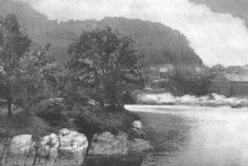
 |
The Falls of the Canajoharie |
On the beautiful Sunday afternoon and evening that I wandered about the rockbound city of Little Falls, I tired to imagine this wild spot as it appeared to the phlegmatic Palatine settlers at Manheim, Danube, and the German Flats in 1722. At that date the rapids and their adjoining shores were in all their primitive grandeur, unadorned or marred by the works of man. Undoubtedly the water power early attracted to their border the saw and grist mills, whose dams probably were an unwelcome barrier to the daring warriors who trusted their lives to the birchen canoe in shooting the rapids. In every direction would have been seen rocks and running water, and rocky hills crowned with the primeval forests. For nearly a mile extended the cascades between perpendicular cliffs from two to four hundred feet high,while at the foot of the rapids the stream was deflected by Moss Island or Moss Rock to pass through a rocky channel about forty feet wide to the placid stream beyond. On the south side of the river the perpendicular face of a cliff one hundred feet high, called Lovers' Leap, threw its dark shadow on the turbulent stream, while to the west, for nearly a miles, the bare, perpendicular, rocky face of a hill four hundred feet high, rose sheer from the shore of the rapids. A story is told of a young Indian maiden and her dusky lover, who, being pursued by a hostile bank of Indians, sprang from this cliff, clasped in each other's arms, preferring death to separation. This occurrence gave to the locality the name spoken of above, but judging from the numbers of Jacks and Jills who now congregate on this elevated spot on summer evenings, it might well be renamed "Lovers' Retreat."
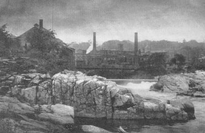
 |
Moss Rock at the Foot of the Rapids, Little Falls |
In 1848 Benson J. Lossing passed down the Mohawk Valley, stopping at points of interest in search of material for his Field Book of the Revolution. His description of Little Falls is very interesting. Among other things he describes a cavern on one of the cliffs which at that period overhung the New York Central Railroad at a point nearly opposite the "Lover's Leap." He says: The rugged shores present many incontestable evidences of abrasion by the violent action of water, thirty to sixty feet above the resent level of the river. Many of them are circular, perpendicular cavities in the hard rocks, which are composed chiefly of gneiss, granite, and horn blends.
On the western (northern) shore of the river a few yards from the railroad and about thirty feet above its bed is a large circular cavity with an opening about ten feet wide facing the river, and over its entrance a massive lintel which appears as if hewn and placed there by the ands of man. Within this cavity, which is open at the top, are smaller ones on its concave side. Indian legends invest these cavities with romantic interest. One of them I will repeat, in brief, as it was told to me, for it is identified with the spot described.
 |
The Ragged Rocks at Little Falls |
Long years ago, when the river was broader and the falls were more lofty, a feud arose between two young chiefs of two of the clans of the Mohawk tribe, the Wolf and Tortoise. A maiden of the Bear Clan was the cause of the feud, as maidens often are. She was loved by both of the young chiefs, and for a time she so coquetted that each thought himself beloved by her in return. (As maidens often do.) Her father was a stern old warrior, and loved his child tenderly. Both chiefs had fought the Mingoes and Mohegans by his side, and the bravery of each entitled him to the hand of the maiden. Her affections were at length stirred by the more earnest importunities of the Wolf, and she promised to become his bride. This decision reached the ears of the Tortoise, and the embers of jealousy which disturbed both while unaccepted suitors, burst into a flame of ungenerous revenge in the bosom of the disappointed lover. He determined to possess the coveted treasure before the Wolf should take her to his wigwam. With well dissembled acquiescence in her choice, and expressions of warm friendship for herself and her affianced, he allayed all suspicions, and the maiden rambled with him in the moonlight upon the banks of the river when her affianced was away, unconscious of danger. The day approached for the maiden to go to the wigwam of her lord. The Tortoise was with her alone in a secluded nook upon the bank of the river. His light canoe was near, and he proposed a voyage to a beautiful little island in the stream, where the fireflies sparkled and the whippoorwill whispered its evening serenade. They launched, but instead of paddling for the island, the Tortoise turned his prow toward the cataract. Like an arrow they sped down the swift current, while the young chief, with vigorous arm paddled for the northern shore. Skillful as with the bow and hatchet, he steered his canoe to the mouth of the cavern described, as then upon the water's brink, seized the affrighted maiden, and leaped ashore, at the same moment securing his canoe by a strong green withe. The cave was dry, a soft bed of skins of beasts was spread, and abundance of provisions were there stored. At the tip of the cave, far above the maiden's reach, an opening revealed a passage through the fissures of the rocks above. It was know only to the Tortoise; and there he kept the maiden many months, until her affianced gave her up as lost to him forever. At length, while hunting on the southern hills in flowery May, the Wolf saw the canoe at the cavern. It solved the question in his mind. The evening was clear, and the full moon shone brightly. He waited until midnight, when, with an arm as strong and skill as accurate as his rival's, he steered his canoe to the mouth of this cavern,which was lighted up by the moon. By its light he saw the perfidious Tortoise sleeping in the arms of an unwilling bride. The Wolf smote the Tortoise, but the wound was light. The awakened warrior, unable to grasp his hatchet, bounded through the opening at the top of the cavern, and closed it with a heavy stone. The lovers embraced in momentary joy. It was brief, for a fearful doom seemed to await them. The Tortoise would return with power, and they had to make choice of death by the hatchet of the rival chief or by the waters of the cataract. The latter was their choice, an din affectionate embrace they sat in their canoe and made the fearful leap. The frail vessel struck propitiously upon the boiling waters, and, unharmed, passed over the gulf below. Down the broad stream they glided, and far away, upon the margin of the lower lake they lived and loved for two generations, and saw their children's children go out to battle and the chase. In the long line of their descent, tradition avers, came Brant, the Mohawk sachem, the strong Wolf of his nation.
 |
The Old Aqueduct, Little Falls |
Since the above was written (in 1848) the New York Central Railroad has been widened at this point, by cutting away the face of the northern cliff, and the Dolgeville Railroad now climbs along an incline, also cut from this cliff, and has undoubtedly destroyed the cavern spoken of above. However, about five hundred feet from the viaduct that carries the last named railroad across a deep ravine at the eastern end of the city, is to be seen what seems to be the back of this cavern, recessed about two feet from the present face of the cliff, and surmounted by a slab or lintel perhaps fifteen feet long and three feet thick, reminding one of an entrance to some rock temple of Indian, as described by travelers. On the tops of both the northern and southern hills are found many pot holes of varying size and depth, plainly indicating that the immense prehistoric streams that flowed through the Mohawk Valley from Lakes Iroquois and Spencer must, at some period, have passed over the highest hills at that point. That there was a very high fall in existence where the foot of the rapids now is, seems to be indicated by the disrupted rocks in that vicinity, and the great depth of water at that point, which is said to be a hundred feet or more.
A very interesting rock is seen near the lower iron bridge, and about one hundred feet from the river bank, and perhaps thirty feet above the present level of the stream. The rock stands about fifteen feet above the surrounding earth and is in the shape of a horseshoe whose outer diameter is about fifty feet, inner diameter about twenty feet, and the width of the horseshoe about fifteen feet, with the opening to the west, or up the stream. The inner surface of this horseshoe or broken circle, which is bowl shape, is perpendicular and marked with segments of a circle all around the inside, plainly showing the rotary motion of water and debris, as it was poured in immense volume from high falls above it. At the eastern end of the inner circle is a pot hole five feet deep and about two feet in diameter. This hole has been worn through the side near the bottom, indicating the manner in which this immense bowl was formed. I have no doubt that the removal of the accumulation of earth and water from the bottom of this bowl would uncover a cavity of remarkable interest.
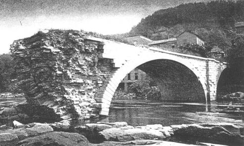
But Little Falls is historic as well as prehistoric. Across the river, below the State dam which feeds the Erie Canal, are the remains of a well constructed shallow aqueduct of seventy feet span, which was formerly used for floating canal boats from the canal to a large basin which was situated on the north side of the Mohawk, back of the present station of the New York Central Railroad. This aqueduct is not longer used, one of the arches having been destroyed.
In a previous chapter, mention is made of the early mode of navigating the Mohawk River and the canal at Little Falls, and from Rome to Wood Creek, and so on through Oneida Lake and Oswego River to Lake Ontario, with tow short portages in Oswego River.
To improve the waterway to the West, the Inland Lock Navigation Company, in 1795, constructed a canal about two miles long, from below the rapids to the deep water above the falls. This canal was cut through the rock on the north bank of the river, and with the aid of five locks batteaux were raised 42 feet and launched into the smooth water above the falls. A small portion is still to be seen in the western part of the city, also the stonework of the two upper guard locks or gates. The canal seems to have been cut through solid rock, was about ten feet wide, and ten feet deep at the upper lock. The width of the old canal indicates the maximum width of the batteaux used by the early navigators.
Copyright © 1998, -- 2003. Berry Enterprises. All rights reserved. All items on the site are copyrighted. While we welcome you to use the information provided on this web site by copying it, or downloading it; this information is copyrighted and not to be reproduced for distribution, sale, or profit.