Three Rivers
Hudson~Mohawk~Schoharie
History From America's Most Famous Valleys
The
Mohawk Valley
Its
Legends and its History
by
Max Reid
New York and London G. P. Putman's Sons
The Knickerbocker Press, 1901
with illustrations from photographs by J. Arthur Maney
Chapter XXI Oriskany
In the month of August, 1777, occurred two of the most important battles of the Revolution, the results of which were finally seen in the surrender at Saratoga of General Burgoyne to General Gates and the victorious Americans, when the campaign, begun with the bombastick proclamation of the British General, who signed his name, "John Burgoyne, Esquire, Lieutenant-General of His Majesty's forces in America, Colonel of the Queen's Regiment of Light Dragoons, Governor of Fort William in North Britain, one of the Commons of Great Britain in Parliament, and commanding an army and fleet on an expedition from Canada, etc., etc.," ended in the complete and humiliating defeat of that windy gentleman. "I have," says the proclamation, "but to give stretch to the Indian forces under my direction, and they amount to thousands, to overtake the hardened enemies of Great Britain and America. I consider them the same where ever they may lurk." The battles I speak of are those of Bennington and Oriskany. It was at the battle of Bennington that he received the first check to his victorious march to Albany through the Champlain Valley, and at Oriskany and Fort Schuyler, the turning back of the attendant expedition to Albany by the way of the Mohawk Valley.
The plan of the Campaign of Burgoyne was arranged in London and provided for a force of four thousand British troops and three thousand German, to which were added some Canadians and a body of Indians. An auxiliary force under Colonel St. Leger was to leave Montreal for Oswego simultaneous with Burgoyne's expedition through the Champlain Valley, and there join a body of Tories under Sir John Johnson and Indians under Brant, who were to clear the Mohawk Valley and join Burgoyne and General Howe (who was to proceed up the Hudson) at Albany.
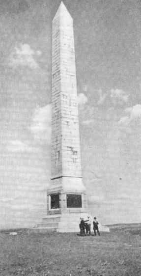 |
The Oriskany Monument. |
In 1758, at the head of boat navigation on the Mohawk River, where the village of Rome now stands, was erected a fort for the protection of the settlers against the French and Indians during the last French War. This was named Fort Stanwix; although strongly built it was found to be untenable at the beginning of the Revolution, and in 1776 a new fort was built and named Fort Schuyler in honor of General Philip Schuyler (This name seems to have been a favorite one for fortifications. In 1709 a fort was erected on the Hudson near Schuylerville, and a little later a rude fort was built on the present site of Utica, both of which were named for Peter Schuyler. The earlier one was destroyed by its builders,and the later, decayed through neglect.) Previous to this, a rude stockade fort stood on this site and was called Fort Williams from its commandant, a Captain Williams. It is spoken of as being well built, having four pieces of cannon and garrisoned with one hundred and fifty men. It was destroyed by General Webb in 1756 after the fall of Oswego. Four miles away on Wood Creek at the western end of the carrying place between said creek and the Mohawk River, was another fort named Fort Bull. March 27, 1756, this was attacked by a party of French and Indians under Monsieur de Lery, the defenders of the fort were massacred, and the fort was blown up and burned. It is said that this fort was rebuilt about tow miles from the present city of Rome and is probably the Fort Bute of the Tryon map of 1779. The siege of Fort Schuyler and the attendant battle at Oriskany form a theme of never ending interest to the dwellers of the Mohawk Valley, many of whose ancestors were active participants in that gruesome engagement. In April, 1777, Colonel Peter Gansevoort, of the New York line, was appointed to the command of Fort Schuyler, and when he reached the post he found the works in an unfinished state and "not only indefensible but untenable." On the 29th of May, Colonel Marinus Willet was directed to join the garrison at Fort Schuyler with his regiment, and, with the active assistance of that officer, Colonel Gansevoort proceeded to put the fort into as defensible state as the circumstances would permit without knowing the character of strength of the enemy they were destined to oppose. The garrison consisted of 950 men, and although they had a plentiful supply of ammunition for small arms, they had only about four hundred rounds for the cannon. In June, information was received from a spy, a friendly Oneida half breed sachem named Thomas Spencer, that a body of troops consisting of seven hundred Indians under command of Joseph Brant and four hundred regulars and six hundred Tories under Sir John Johnson and Colonel John butler, the whole force under command of Colonel St. Leger, were to rendezvous at Oswego and from thence proceed to the Mohawk Valley with fort Schuyler as their objective point. This information instead of arousing the phlegmatic Germans of the upper valley to prompt and efficient action, seemed to paralyze them with fear. The timid became backward in preparing for the field, while the wavering became Loyalists, or at the best passive Whigs. To counteract this effect General Herkimer issued a stirring proclamation informing the inhabitants of the gathering of the enemy's forces at Oswego and calling upon all between the ages of sixteen and sixty to hold themselves in readiness to repair to The field, while the invalids and those over sixty years of age were directed to arm themselves for the defense of the women and children, and for the protection of their homes. The disaffected were also ordered to be arrested and disarmed. The appeal was not without its effect, and the militia and the people, stimulated by the near approach of danger, moved with a degree of alacrity which contrasted strongly with their former apathy.
On the 3d of August, Colonel St. Leger arrived before the fort with his whole force of blatant Tories and howling savages, and a pompous demand was sent to Colonel Gansevoort which dealt liberally in threats of vengeance to those who refused to recognize the King and submit to his authority. No notice being paid the demand, hostilities commenced on the morning of the 4th of August. St. Leger at this juncture sent a dispatch to General Burgoyne expressing his assurance that Fort Schuyler would be in his possession directly, and the hope that they would meet as victors at Albany.
An interesting episode is connected with this siege which I think is not generally known. On the 14th of June, 1777, Congress ordained that the flag of the thirteen United States should be thirteen stripes, alternate red and white, and that the union be thirteen white stars on a blue field. In August, 1777, Fort Schuyler was without a flag when the enemy appeared, but their pride and ingenuity were equal to the occasion. The white stripes were made from strips cut form shirts,t he red from bits of scarlet cloth, and the blue ground for the stars, from a cloak belonging to Captain Abraham Swartout, of Dutchess County. This is thought to have been the first flag of the regulation stars and stripes that was raised above a fort in the United States.
The arrival of St. Leger at Fort Schuyler soon became known through the Mohawk Valley, and General Herkimer summoned the inhabitants in accordance with his proclamation. They nobly responded; not only the militia, but the gentlemen of the county and members of the Committee of Safety hastened to Fort Dayton, now Herkimer, and on the 5th day of August, when the Indians invested Fort Schuyler and by their hideous yells attempted to intimidate the garrison, Herkimer was at Whitestown, eight miles from the fort, with eight hundred undisciplined but brave and enthusiastic troops eager to face the enemy, having crossed to the south side of the Mohawk at old Fort Schuyler (Utica).
While the party remained at that place General Herkimer sent Adam Helmer and two trusty men to apprise Colonel Gansevoort of his approach and concert measures of cooperation. Three successive discharges of cannon were to announce the arrival of the couriers, which he knew could be plainly heard at the encampment. Having experienced considerable difficulty in approaching the fort, Adam Helmer did not succeed in entering until ten o'clock on the morning of the 6th. The signal guns were immediately fired, and, as the message of General Herkimer intimated his intention to force a passage to the fort, a sortie was immediately arranged for the purpose of diverting the attention of the enemy.
On the 4th, when Herkimer and his troops left Fort Dayton, Thomas Spencer, the faithful Oneida, was with him. Noticing the impetuosity of the men and the total disregard to all order of marching, without reconnoitering or throwing out flanking parties, he insisted upon these precautionary measures being adopted, in which he was joined by General Herkimer and some of the older officers. The junior officers ridiculed the idea and General Herkimer, contrary to his own judgment, did not enforce the order.
On the morning of the 6th, a renewal of these scenes took place in Herkimer's camp. With the same caution which the General had previously manifested, he desired to remain where he was until some evidence was received that a movement from the fort had been made. The new born zeal of his junior officers revolted at the idea, and angry words ensured, in which the brave but cautious man was denounced by Colonels Cox and Paris as a coward and a Tory. This bitter taunt sank deep into his heart, but he answered calmly, "I am placed over you as a father and guardian, and I will not lead you into difficulties from which I may not be able to extricate you.' There was a brief interchange of further hot words between the General, Colonel Bellinger, and John Frey on one side, and the mutinous colonels and men on the other, while the old man stood defiant, with chin raised and dark blazing eyes. The confusion became unbearable and the shouts of "Lead on! Lead on!" from the crowd more vehement. Suddenly Herkimer sprang upon a log, too much incensed to control himself and cried, "If you will have it so, the blood be upon your heads." Waving his sword, he shouted in a voice all the eight hundred could hear, "Vorwarts!" Instantly, with exultant cheers, the men rushed for their arms, officers their horses, and the teamsters the baggage train, everyone eager to reach the enemy without regard to their order of going. Through the efforts of the General the four regiments were brought into a semblance of order, with Colonel Visscher and the Caughnawaga company in the rear as guard of the ammunition and supply wagons, and so, marching swiftly and without scouts, at nine in the morning they started forth.
Information of the approach of General Herkimer having reached Colonel St. Leger on the evening of the 5th, and the latter preferring to receive him in the field rather than in his camp, detached eighty men of Sir John Johnson's Royal Greens, under Major Watts, Sir John's brother-in-law, and the entire body of Indians under Joseph Brant, the whole under command of Sir John Johnson, to intercept his approach. It appears that the influence of Brant prevailed, and that it was determined to draw the Americans into an ambuscade. For this purpose, with a sagacity which does even that remarkable man great credit, a position was selected which was admirable adapted for his purpose about two miles west from Oriskany and six from Whitesboro. At this place were two short ravines running from south to north both opening to the north and separated by a level plateau of perhaps ten acres about fifty feet above the bottom of the ravines. This plateau gradually narrowed to a rounded point as the ravines opened out and gradually merged into the swampy flats that stretch north to the Mohawk River three-quarters of a mile away. The westernmost ravine was the rendezvous of the British troops, who were stationed along its upper eastern edge, effectually concealed by its fringe of low trees and bushes. The Indians rapidly took their positions around the south, north, and eastern edge of the easterly ravine, nearly enclosing it except where the rude road of logs (constructed earlier in the year by colonel Gansevoort for easier carriage of cannon and supplies for Fort Schuyler, six miles away) ran down and over the swampy bottom of the fatal ravine. All around were threes and low bushes and the attendant rotting logs and tree trunks, while tangled masses of dead branches and underbrush bordered each side of the rough road that stretched out east and west until lost in the gloom of the forest, while the swampy flats, dimly seen through the mouth of the ravine, were covered with tall swamp grass and the long, flat leaves of cattail and calamus, with here and there a scrub pine or willow, making a treacherous concealment for the naked savages. Occasionally a group of pond lilies and other aquatic flowers added color and beauty to the diversified landscape.
 |
Oriskany Battlefield, East side of Ravine. Herkimer's troops were massed at the log Road through the swamp. Swamp in the foreground. |
Meanwhile General Herkimer had moved on from the mouth of Oriskany Creek entirely unconscious of the ambuscade two miles away. Their route lay along the firm lowlands for about a mile, the road gradually bearing to the south and up the low forest covered hills that led to the fatal ravine. The morning was dark, sultry, and lowering, and the muttering of distant thunder was in the air, unheeded or unnoticed by the troops whose minds were intent upon reaching the fort.
The Canajoharie regiment, with General Herkimer and Colonels Cox and Paris in the van, was the first to reach the eastern edge of the slope down which the corduroy road ran to the marshy bottom of the ravine.
The general and the colonels spoken of above seem to have been at the head of the troops down this rough road, followed in a joyous and rollicking manner by the three regiments and the baggage train. The van had nearly reached the top of the western slope and the balance of the troops were huddled together at the narrow crossing,and the baggage train was waiting for an opportunity to cross. Colonel Visscher with the Caughnawaga company was yet on the top of the hills waiting for the bridge or ford to become cleared before descending. Those on the other side were looking back to see the wagon making its way down the hill. Colonel Cox was giving an order to those below when the report of a rifle was heard and Colonel Cox fell headlong upon the neck of his horse, which turned and at a mad gallop dashed down the slope and into the startled crowd at the fort. Instantly, as though the rifle shot had been a signal for action, swarms of red devils dashed upon the Visscher company, firing and yelling as if in hellish delight, separating them from the troops below, and fairly overwhelming them with superior numbers, at the same time completing the cordon that was drawn around the doomed Americans in the valley below, while from every tree and bush ran out the report of rifle and the war cry of the Indians.
Then ensued a scene of direct confusion, as the troops at the crossing realized that they were completely surrounded by the hordes of naked, pained, savage devils, with apparently no avenue of escape. At the first discharge many had been killed while others, wounded, had fallen into the slimy marsh either to be drowned or to receive the death stroke by hatchet, or knife from the foe who became bold at the evidently helpless situation of the soldiers.
To return a moment to Colonel Visscher and part of the Caughnawaga company who had become separated from the main body of troops. Finding themselves assailed on three sides the company rapidly retreated, firing as they went, behind three and bush in true backwoodsmen fashion, drawing the Indians after them, who were intent upon their death or capture and neglecting for the time being their duty on the hilltop in their frenzied pursuit.
General Herkimer, although taken by surprise, seems to have risen equal to the occasion. Urging his horse down the hill slope, with energetic efforts he succeeded in pulling the troops who had already crossed up to the level plateau where they were met by the fire of Sir John Johnsons' Rangers in front, along the top of the second ravine, and the fire of the Indians concealed on both flanks. Noticing that the fire from along the eastern slope of the ravine was thin and somewhat irregular, he ordered Colonel Bellinger and the soldiers who had not yet crossed the causeway to retake the hill. Dashing through the hail of lead on both flanks the stalwart Palatine Germans stormed the hillside firing to kill as they went and then meeting their antagonists with the swinging blows of clubbed muskets. Regaining the hilltop, they formed themselves into circular squads, leaving the bottom of the fatal raving to the dead and dying,and the occasional prowling painted savage with ready knife searching for scalps and plunder.
It was at the time that Herkimer had succeeded in getting the regiment in some sort of order on the plateau that he received the bullet through his leg which at the same time killed his horse. He was taken up and carried up the slope to the plateau and placed upon his saddle at the foot of a large beech tree, where, having lighted his pipe he sat and continued to order the battle with the utmost firmness and composure until the enemy retreated. For three-quarters of an hour the contest continued with fury on both sides. At that time the enemy began to concentrate his forces and by slow degrees to close upon the Americans from all points of the circle. Noticing this movement the Americans on the plateau formed themselves into circles and their resistance from that moment became more effective. To counteract it, the fire of the Tories was discontinued and the enemy charged with the bayonet; and then more than ever before the contest became a death struggle, hand to hand and foot to foot. Never did brave men stand a charge with more dauntless courage, and the enemy made no impression.
At this moment a blinding flash followed by a crashing peal of heaven's artillery burst upon the ears of the combatants. Intent upon the battle, the approach of the thunder storm had been unnoticed until it burst upon them with inconceivable fury. The roaring wind, the swaying of the tree tops, and the sudden downpour of rain arrested the work of death and drove both Indians and whites to seek shelter under trees and bushes. For nearly an hour rain fell in torrents; but even the vivid lightning, the furious wind, the rolling thunder, and the crashing of falling trees, did not prevent the Americans from making preparations to renew the deadly struggle. The wounded bound up their wounds, every musket was carefully loaded and protected from the rain, each soldier refreshed himself with water and food, and waited impatiently for the cessation of the storm.
General Herkimer had formed the American farther up the plateau towards the south and had succeeded in withdrawing the troops under Colonel Bellinger and Captain Jacob Gardinier from the east side of the ravine. Formed into a circle, each man protected by tree or log, they were ordered to adopt a new mode of bush fighting to counteract the operations of the Indians, who, as soon as they saw a gun discharged from being a tree rushed upon and tomahawked the marksman before he had time to reload. To prevent this, General Herkimer ordered two men to tack each tree, one to fire at a time and the other to reserve this fire for the Indian who might seek their scalps.
In imagination I can see the bluff, rugged old man, whose tawny Saxon hair veils the silver-gray locks that would be a fitting crown for his years of life. His angular form and hardened muscles indicate laborious toil and exposure, while the slow, automatic movements of his limbs are those acquired by following the plough or picking his way over broken farmland. On his bronzed, careworn face is a look of pain, but his firm, eager eyes scan every movement of this beleaguered troops and the red skinned enemy. His commands are given sharp and short, like the quick blue puffs of smoke from this short black clay pipe.
It is pleasant to note that, however rebellious his impetuous men appeared on the march, his orders are now obeyed with the utmost confidence in the judgment and loyalty of their much abused leader.
His buff faced blue coat and vest, are disordered and blood stained, and his wounded leg nearly bare, bound with a red silk handkerchief, while his neck and breast are uncovered to the hot, sultry air.
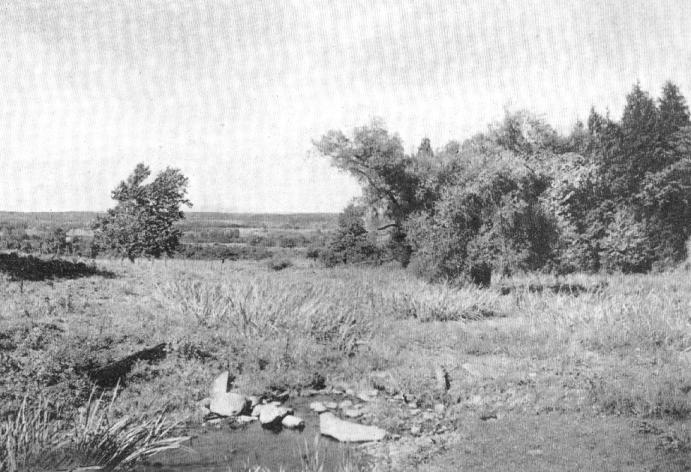 |
The Oriskany Battlefield, with remains of old wood road in the foreground. |
The storm at length passed over, and amidst one of the most intensely hot days the battle was renewed with increasing fury. The new position of the Americans, and the new system of bush fighting, however, soon produced their legitimate results, and the Indians suffered severely, so much so, indeed, that they began to show signs of uneasiness, and Major Watts moved forward a second detachment of Royal Greens, which had been sent out by Colonel St. Leger, to support them. These men were Tories, any or nearly all of them from Tryon County and former neighbors of the men they were marching against, and as they advanced so near as to afford mutual recognition, the contest became if possible more terrible than before. Mutual revenge and hate raged in their bosoms. The American fired upon them as they advanced, and then springing from their covers attacked them with bayonets and clubbed muskets, or in some cases with knife or bare hands, throttling and stabbing each other, and sometimes dying in each other's embrace. It was at this time that the signal guns were heard from the fort, an evidence to the American of the sortie asked for by General Herkimer and anxious to close the engagement Colonel Butler executed a stratagem that nearly accomplished that object. He so changed the dress of a detachment of Royal Greens that they resembled Americans, using the hats of the dead patriots for the purpose. These men were made to approach from the direction of the fort and were at first mistaken for reinforcement from the garrison. Directly in their path was Captain Jacob Gardinier and some of his Caughnawaga men. The burly captain, his only weapons his knife and short spear, was fighting with a group of Tories and Indians, while around him lay four of the enemy slain by his hand. His experienced eye discovered the real character of the approaching masquerade and ordering his men to fire upon them and rushing upon them himself, followed by some of his men, upwards of thirty of the Tories were slain and the remainder fled in disorder. The Indians perceiving with what order the American opposed the enemy, tired and sulky after six hours furious fighting, raised the retreating cry of "Oonah! Oonah!" and fled in every direction, while the Tories, perceiving that their allies had deserted them, also retreated, leaving the Tryon county militia and volunteers master of the field.
After the action General Herkimer was taken to his own house, which is still standing, about three miles east of Little Falls on the south bank of the Mohawk River, where his leg was amputated nine days after the battle. It is said to have been done in the most unskillful manner, the leg having been cut off square, without allowing flesh enough below the bone to form the proper flaps to cover the wound, whereby the flow of blood was with difficulty stanched. Colonel Willet called to see him soon after the operation and found him sitting up in his bed, as cheerful as usual, smoking his pipe. Hemorrhage ensued and toward evening the General became convinced that his end was near. He called for his Bible and read composedly in the presence of his family and other the thirty-eighth psalm, applying the penitential confessions to his own case. His voice gradually grew weaker, the book slipped from his nerveless fingers,and sinking back on his pillow General Herkimer, a Christian hero, died.
A description of the Mohawk Valley in 1757 is found in the documentary history of New York.
The writer starts from Chouegren (Oswego) and follows the Oswego and Oneida rivers to Oneida Lake thence through the lake to Wood Creek which he ascends to Fort Bull and thence across the carrying place to Fort William (Rome) on the Mohawk River. Sailing, or rather, poling, down the river he reaches Fort Kouari (Fort Herkimer) on the right or south bank of the river. This fort is thus described: It is a large three story stone building with port holes at each story and likewise in the basement for cross firing. There are some small pieces above. The house is covered with plank and shingles. It is built as a store and depot for Cheouegn (Oswego). It is surrounded by a ditch at a distance of about thirty feet. This ditch is six feet deep and seven feet wide. The crown of the ditch is planted with palisades in an oblique form, behind these there is a parapet of earth so as to be able to fire over the palisades. The four angles of this parapet which is at the back of the ditch, form as it were four little bastions that reciprocally flank each other. On the west side is a house apart from the large one. It backs against the parapet of the palisades, and serves as a barrack and guard house. There are tow doors to the large building, the one on the north is a small swing door. The large door of the house is on the south side. Opposite this fort is a small cultivated island which can be reached at low water by fording.
From Fort Kouari to Fort Canajoharie (Indian Castle) is four leagues. The inhabitants of this country are Palatines or Germans. Fort Canajoharie is situated on the south side of the Mohawk River. It is a square of four bastions of upright pickets joined with lintels. They are fifteen feet high, about one foot square, with port holes inserted from distance to distance, with a stage all round to fire form. The fort is one hundred paces on each side. It is not surrounded by a ditch. There are some small pieces of cannon at each of its bastions and a house at each curtain to serve as a store and barrack. Five or six families of Mohawk Indians reside outside the fort. (This fort was built in 1756 by Sir William Johnson.) Previous to that time there was a block house situated on a hill on the opposite side of the creek. Indian Castle was the home of Joseph Brant and King Hendrick and Molly brant after Sir William Johnson' death until the flight of the Mohawks to Canada. It is said that Molly Brant furnished her brother with valuable information in regard to General Herkimer's movements previous to the battle of Oriskany.
The distance from the above fort to Fort Hunter is about twelve leagues. About one hundred houses at a greater of less distance are found within this length of road. There are some situated about half a league in the interior. The inhabitants of this section compose a militia company of one hundred men. Fort Hunter is situated on the border of the Mohawk River and is of the same form as that of Canajoharie, with the exception that it is twice as large. There is a church or temple in the middle of the fort (Queen Anne's Chapel).
From Fort Hunter to Chenectadi, or Corlear, is seven leagues, and twenty or thirty houses are found within this distance. The inhabitants of this section are Dutch. They form a company with some others on the left bank, about one hundred strong.
Chenectadi or Corlear is situated on the bank of the river and is a village of about three hundred houses.
From Chenectadi to Orange (Albany) is estimated to be six or seven leagues. This is all that relates to the right or south bank of the Mohawk.
Beginning again at Fort Williams, Rome, the record describes the country along the left or north bank of the Mohawk: Leaving Fort Williams, the village of the Palatines is estimated to be twelve leagues. (All the country between Little Falls and Rome, on both sides of the Mohawk, was known as the German Flats and was the home of most of the Palatines that moved from Schoharie Valley in 1722. The Palatine village was known as "German Flats," and was situated about a half-mile above Fort Kouari on the opposite bank, now know as Herkimer. During the revolution a fort was built at Herkimer and called Fort Dayton.)
In 1757 the Palatine village, which consisted of thirty houses, was destroyed and burnt by a detachment of about three hundred Indians and Frenchmen under M. de Bellestre. The inhabitants of this village formed a company of one hundred men bearing arms. Total population about three hundred men, women, and children, one hundred and two of whom were made prisoners, and the remainder fled to Fort Kouari, except a few who were killed while fording the river.
From Palatine village to the Little Falls, still continuing on the left bank of the Mohawk, is estimated about three leagues. In this distance, there are but eight houses, which have been abandoned. The portage at Little Falls is a quarter of a league and is passed with carts.
From the portage to Colonel Johnson's mansion is twelve leagues. In the whole of this distance the soil is good. About five hundred houses are erected at a distance one from the other. The greater number of those on the bank of the river are built of stone. Those at a greater distance from the river in the interior are about half a league off; they are new settlements and are built of wood.
(Two of these old stone buildings are still to be seen from New York Central trains north of the track, the Ehle house, east of Fort Plain, built in 1752, and the Frey house, west of Palatine Bridge built in 1739.)
There is not a fort in the whole distance of twelve leagues. There is but one house, built of stone, that is somewhat fortified and surrounded with pickets (the Frey house). The inhabitants are Germans, They form four companies of one hundred men each.
Colonel Johnson's mansion is situate on the border of the left bank of the Mohawk River; it is three stories high (two stories and attic), built of stone with port holes and a parapet, and flanked with four bastions on which are some small guns. In the same yard on both sides of the mansion, there are two small houses; that on the right of the entrance is a store, and that on the left is designed four workmen, Negroes, and other domestics. The year gate is a heavy swing gate well ironed; it is on the Mohawk River side; from this gate to the river there is about two hundred paces of level ground. (It is said that the buildings were enclosed in a stockade during the French war.) A small rivulet coming from the north empties itself into the Mohawk about tow hundred paces below the enclosure of the yard. (The Kayaderos Creek, said to have given the name to the famous patent.) On this stream there is a mill about fifty paces distant from the house, below is the miller's house,and on the other side of the creek one hundred paces from the mill is a barn in which fodder and cattle are kept. One hundred and fifty paces from Colonel Johnson's mansion at the north side, on the left (east) bank of the little creek, is a little hill on which is a small house with port holes where is ordinarily kept a guard of hone of some twenty men,which serves also as an advance post.
From Colonel Johnson's house to Chenectadi is counted as seven leagues. The road is good, all sort of vehicles pass over it. About twenty houses are found from point to point on this road.
The Mohawk River can be forded during summer a league and a quarter west of Chenectadi. Opposite Chenectadi the traverse is usually by a ferry boat and batteaux.
Going from Chenectadi to the mouth of the Mohawk River where it discharges into the Orange (Hudson), there is a Great Fall (Cohoes), which prevents the passage of bateaux, so that everything on the river going from Chenectadi to Orange (Albany) passes over the highroad that leads there direct.
In the whole country of the river Corlear (Mohawk) there were nine companies of militia under command of Colonel Johnson; eight only remain, that of the village of the Palatines being no longer in existence, the greater portion having been defeated by M. deBellestre's detachment.
Colonel Johnson assembles these companies when he has news of any expedition which may concern the Mohawk River.
In the latter part of April 1757, on receiving intelligence by the savages that there was a strong detachment ascending the river St. Lawrence and entering Lake Ontario, he assembled these companies and went to the village of the Palatines where he was joined by another body of twelve hundred men sent him by the commandant of Orange; this formed in all a force of two thousand men, he entrenched himself at the head of the Palatine village where he remained in camp fifteen days, and did not retire until he received intelligence that the French detachment seen on the St. Lawrence River, had passed by and taken the route to Belle Riviere (Ohio).
In 1900, a century and a half after the above record was made, in company with Prof. J. A. Maney, I traversed the same section of the Mohawk, not by bateaux and rude carts, but by railroad, in true nineteenth century style. The objective point was Rome, in search of data in relation to the battle of Oriskany and the siege of Fort Schuyler. We did not succeed in finding any evidence of the fort, in fact, we had some difficulty in finding any one that had ever heard of it. We were finally, however, directed to its site, in the center of the city and near the border of the Mohawk River. Nothing remains to mark the spot of that heroic resistance of a handful of sturdy pioneers who by their valor turned back to Canada the hordes of savages and Tories under St. Leger, Sir John Johnson, Butler, and Joseph Brant, and thereby assisted materially in defeating the plans of General Burgoyne, and thus led to the surrender of the British troops at Saratoga.
At glance at the map of New York State will show that the Mohawk River rises just over the border of Lewis County in the town of Lewis and under the shadow of Mohawk Hill. Although flowing in a southerly direction until it reaches the vicinity of Rome, like many a mountain stream with its numerous curves it seems to flow in the direction of every point of the compass. West of Rome is a small stream running parallel with the Mohawk called Wood Creek, distant from said river about two miles. The slight elevation of land between, however, is sufficient to turn the waters of Wood Creek and Oneida Lake and through Oswego River to Lake Ontario, and thence to the Gulf of St. Lawrence. The Mohawk bending to the east finally reaches the Atlantic Ocean through the Hudson River and New York Bay.
There were two routes for the Indians in their birchen canoes to the Mohawk Valley, one by the way of Lake Champlain and Lake George, and the other up the St. Lawrence and around the east coast of Lake Ontario to Oswego River, thence up the river and Oneida Lake to the mouth of one of its small tributaries, Wood Creek, thence up Wood Creek to a point two miles from the present site of the city of Rome where the canoes were carried across the divide to the Mohawk River,and thence down to the Hudson.
When the Dutch established themselves in the lower Mohawk Valley, hunters and traders, the courreur de bois of the Dutch, used the Mohawk River and the Indian canoe to penetrate to the home of the Iroquois in quest of game and furs.
As the valley became settled by venturesome resident traders, supplies were transported to them in canoes or flatboats which on their return brought peltries, potash, and the produce of their limited acres.
Niagara, or Onjagara, as it was called by the Iroquois, early became an important trading post with the farther Indians both to the English and French, and the establishment of a post at Irondequet, and the building of a fort at Chouegen (Oswego) in 1725 called for improvements in the mode of navigating the Mohawk. Flat boats called bateaux were constructed and propelled by paddles, polies, and sail. But it was not until 1792 that the Inland Lock and Navigation company made any decided improvements in the river bed and carrying places. At that time the channel was deepened, canals dug at Little Falls, and across the carry between Wood Creek and the Mohawk River. I have often thought that this work was probably the incentive to Governor Clinton to build he "big ditch" a quarter of a century later.
After this long digression, we will continue our journey from Rome, eastward.
From the very start we found difficulty in tracing the channel of the river from the windows of the car. For forty-five miles the river runs its tortuous, erratic course, marked by its borders of low willows and occasional majestic elms, through the German Flats, or, until it reaches the vicinity of Herkimer. We were impressed with the uniform width of its channel, which has the appearance of the Erie Canal before it was enlarged. In fact its channel through the German Flats seems to retain evidence of work done by the Inland Lock and Navigation Company. For a number of miles we have been steaming along the south bank of the river, but a short distance east of Utica we cross to the north side and so continue on to our journey's end. (This is probably the place where Herkimer crossed the Mohawk with his troops en route for Fort Schuyler.)
A little earlier in the day we had left the New York Central at Oriskany, en route to the battlefield and the scene of the fatal ambuscade. A hurried departure from Rome obliged us to leave the table at the Stanwix before dinner was served, and although our ruffled tempers were somewhat smoothed by the hurried eating of a sandwich hurriedly made, we still felt the need of victuals and drink. Although this quiet little village with its famous battlefield along its borders could not supply us with all that we desired, we however succeeded at last in securing a vehicle for our two miles' ride over the hills to the fatal ravine, and, with the sheriff of Oneida as our guide and factotum, and with the rattle of wagon spokes that kept time to the beat of the horses' hoofs, followed nearly the same route as Herkimer and his impetuous soldiers. The weather was all that could be desired, but the landscape view was not very inspiring as we were at least a mile away from the range of low hills that mark the north boundary of the valley and the only evidence of the Mohawk River was a line of low bushes about three-quarters of a mile away, while apparently limitless miles of flat land seemed to stretch away east and west.
But is was the ravine that was the object of our pilgrimage. As we neared the spot, the tall granite monument, eighty feet high, erected by the Oneida County Historical Society in 1876, met our sight and marked the spot we were in search of. A few minutes more and the ravine, the adjacent hills, and the fatal morass were before us.
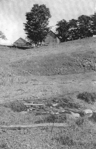
At present the ravine is spanned by a causeway over which passes the main road from Utica to Rome. A narrow arch of stone under the causeway forms a passage for the small creek that produces the morass and swampy flats to the north. A narrow ditch now confines the stream and makes comparatively dry the spot at the bottom of the ravine where the corduroy road formerly crossed, although the western slope half way to the top, still gives evidence of the marshy character of the soil
Accompanying this sketch are photographs of this historic spot, which I trust will enable the reader to comprehend the locality of the battlefield. The first picture shows the eastern hill and slope to the rivulet below, which is seen at the lower right hand corner. On each side of the rivulet is still seen portions of the old log road, which marks the spot where the slaughter of the American troops was the greatest, as they were massed near the only crossing that led through the morass. At the time of the attack all of the troops except Colonel Visscher's Caughnawaga regiment were in the hollow and climbing the western slope. The baggage wagons were yet toiling down the eastern slope and Visscher's men were massed where the farm buildings are seen at the top of the hill. Both hills were covered with tall pines, oaks, and maples while the bottom of this little valley was covered with low trees, bushes, and swamp grass.
At the present time these hills and the surrounding country are entirely cleared of the forest, and cultivated land is seen in every direction. Even the field where the great struggle and subsequent victory took place is now occupied by a thrifty potato patch.
On the eastern plateau is the Battle Monument and in the center of the photograph, on the horizon line is a black mark that looks like a crooked ten-penny nail. This is the picture of the writer, marking the spot where formerly stood the tree under which the wounded General sat directing the battle and one of the group at its base is pointing out the fatal ravine to a party of visitors who were born and brought up at the old village at Whitestown, six miles away, but were ignorant of the circumstances of the battle or the points of interest that surrounded us. This is not at all singular, but is only another evidence of the all absorbing spirit of the twentieth century, the living for the present and the temporal care for the future, and the willingness to leave the past to aged dreamers whose only pleasure, alas, may be the dreams of earlier days.
Copyright © 1998, -- 2003. Berry Enterprises. All rights reserved. All items on the site are copyrighted. While we welcome you to use the information provided on this web site by copying it, or downloading it; this information is copyrighted and not to be reproduced for distribution, sale, or profit.