Chapter One, Part Two
We were detained at Houghton's the following day by a heavy
rain. On the morning after, the clouds 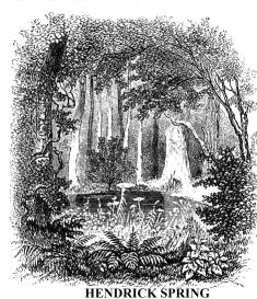 drifted
away early, and with our new and excellent guides, Mitchell Sabattis and William
Preston, we went down the lake eight miles, and landed at a "carry"--as
the portages are called--on its eastern shore, within half a mile of Hendrick
Spring (so named in honour of Hendrick Hudson), the most remote source of
the extreme western branch of our noble river. To reach water navigable with
our boats, we were compelled to walk through forest and swamp about two miles.
That was our first really fatiguing journey on foot, for to facilitate the
passage, we each carried us much luggage as possible.
drifted
away early, and with our new and excellent guides, Mitchell Sabattis and William
Preston, we went down the lake eight miles, and landed at a "carry"--as
the portages are called--on its eastern shore, within half a mile of Hendrick
Spring (so named in honour of Hendrick Hudson), the most remote source of
the extreme western branch of our noble river. To reach water navigable with
our boats, we were compelled to walk through forest and swamp about two miles.
That was our first really fatiguing journey on foot, for to facilitate the
passage, we each carried us much luggage as possible.
We found Hendrick Spring in the edge of a swamp--cold, shallow,
about five feet in diameter, shaded by trees, shrubbery, and vines, and fringed
with the delicate brake and fern. Its waters, rising within half a mile of
Long Lake, and upon the same summit level, flow southward to the Atlantic
more than three hundred miles; 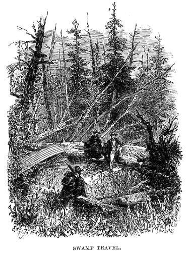 while
those of the latter flow to the St. Lawrence, and reach the same Atlantic
a thousand miles away to the far north-east. A few years ago, Professor G.
W. Benedict (who was connected with the State Geological Survey) attempted
to unite these waters by a canal, for lumbering purposes, but the enterprise
was abandoned. We followed the ditch that he had cut through the swamp nearly
half a mile, among tall raspberry bushes, laden with delicious fruit, and
for another half mile we made our way over the most difficult ground imaginable.
Dead trees were lying in every direction, some charred, others prone with
black ragged roots, and all entangled in shrubbery and vines. Through this
labyrinth our guides carried their boats, and we quite heavy packs, but all
were compelled to rest every few minutes, for the sun was shining hotly upon
us. We were nearly an hour traveling that half mile. Thoroughly wearied, we
entered one of the boats at the first navigable point on Spring Brook, that
flows from the Hendrick source, and rowed leisurely down to Fountain Lake,
while our guides returned for the remainder of the luggage and provisions.
The passage of that portage consumed four hours.
while
those of the latter flow to the St. Lawrence, and reach the same Atlantic
a thousand miles away to the far north-east. A few years ago, Professor G.
W. Benedict (who was connected with the State Geological Survey) attempted
to unite these waters by a canal, for lumbering purposes, but the enterprise
was abandoned. We followed the ditch that he had cut through the swamp nearly
half a mile, among tall raspberry bushes, laden with delicious fruit, and
for another half mile we made our way over the most difficult ground imaginable.
Dead trees were lying in every direction, some charred, others prone with
black ragged roots, and all entangled in shrubbery and vines. Through this
labyrinth our guides carried their boats, and we quite heavy packs, but all
were compelled to rest every few minutes, for the sun was shining hotly upon
us. We were nearly an hour traveling that half mile. Thoroughly wearied, we
entered one of the boats at the first navigable point on Spring Brook, that
flows from the Hendrick source, and rowed leisurely down to Fountain Lake,
while our guides returned for the remainder of the luggage and provisions.
The passage of that portage consumed four hours.
Fountain Lake is the first collection of the waters of the west branch of the Hudson. It is about two miles in circumference, with highly picturesque shores. It empties into Catlin Lake through a shallow, stony outlet. From both of these we had fine views of the near Santanoni Mountains, and the more distant ranges of Mount Seward, on the east. At the foot of Fountain Lake is another "carry" of a mile. A few rods down its outlet, where we crossed, we found the remains of a dam and sluice, erected by Professor Benedict, to raise the waters so as to flow through his canal into Long Lake, and for another purpose, which will be explained presently. The sun went down while we were crossing this portage, and finding a good place for a camp on the margin of a cold mountain stream in the deep forest, we concluded to remain there during the night. Our guides soon constructed a shelter with an inverted boat, poles, and boughs, and we all slept soundly, after a day of excessive toil.
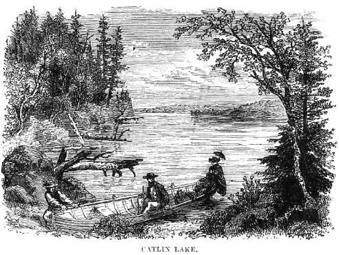 In
the morning we embarked upon the beautiful Catlin Lake, and rowed to its outlet--three
miles. After walking a few rods over boulders, while our guides dragged the
boats through a narrow channel between them, we re-embarked upon Narrow Lake,
and passed through it and Lilypad Pond--a mile and a half--to another "carry"
of three-fourths of a mile, which brought us to the junction of the Hudson
and Fishing Brook. This was a dreary region, and yet highly picturesque. It
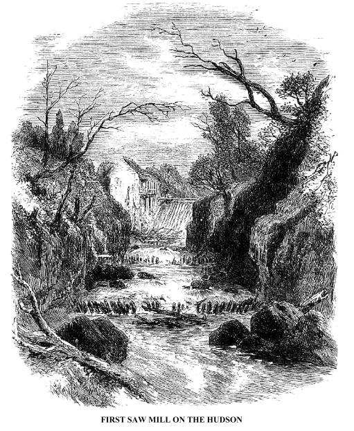
was now about noon. Sabattis informed us that, a little way up the Fishing
Brook, were a clearing and a saw-mill--the first on the Hudson.
In
the morning we embarked upon the beautiful Catlin Lake, and rowed to its outlet--three
miles. After walking a few rods over boulders, while our guides dragged the
boats through a narrow channel between them, we re-embarked upon Narrow Lake,
and passed through it and Lilypad Pond--a mile and a half--to another "carry"
of three-fourths of a mile, which brought us to the junction of the Hudson
and Fishing Brook. This was a dreary region, and yet highly picturesque. It
was now about noon. Sabattis informed us that, a little way up the Fishing
Brook, were a clearing and a saw-mill--the first on the Hudson.
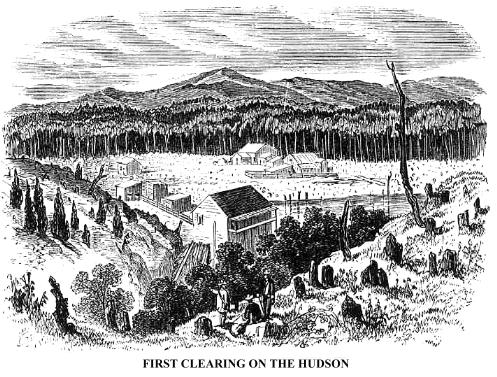
We walked about half a mile through the woods to see them. Emerging from the forest, we came to a field filled with boulders and blackened stumps, and, from the summit of a hill, we overlooked an extensive rolling valley, heavily timbered, stretching westward to the Windfall Mountains, and at our feet were the Clearing and the Saw-mill. The latter stood at the head of a deep rocky gorge, down which great logs are sent at high water. The clearing was too recent to allow much fruit of tillage, but preparations were made for farming, in the erection of a good frame dwelling and outhouses. The head waters of this considerable tributary of the Upper Hudson is Pickwaket Pond, four miles above the mill.
 A
short distance below the confluence of the Hudson and Fishing Brook, we entered
Rich's Lake, an irregular sheet of water, about two miles and a half in length,
with surroundings more picturesque, in some respects, than any we had visited.
From its southern shore Goodenow Mountain rises to an altitude of about fifteen
hundred feet, crowned by a rocky knob. Near the foot of the lake is a wooded
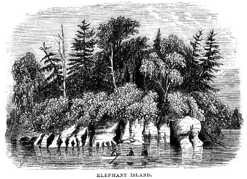
peninsula, whose low isthmus, being covered at high water, leaves it an island.
It is called Elephant Island, because of the singular resemblance of some
of the limestone formation that composes its bold shore to portions of that
animal. The whole rock is perforated into singularly-formed caves. This, and
another similar shore a few miles below, were the only deposits of lime-stone
that we saw in all that region.
A
short distance below the confluence of the Hudson and Fishing Brook, we entered
Rich's Lake, an irregular sheet of water, about two miles and a half in length,
with surroundings more picturesque, in some respects, than any we had visited.
From its southern shore Goodenow Mountain rises to an altitude of about fifteen
hundred feet, crowned by a rocky knob. Near the foot of the lake is a wooded
peninsula, whose low isthmus, being covered at high water, leaves it an island.
It is called Elephant Island, because of the singular resemblance of some
of the limestone formation that composes its bold shore to portions of that
animal. The whole rock is perforated into singularly-formed caves. This, and
another similar shore a few miles below, were the only deposits of lime-stone
that we saw in all that region.
At the outlet of Rich's Lake were the ruins of a dam and lumber
sluice, similar in construction and intended 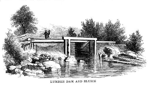 use
to that of Professor Benedict at Fountain Lake. The object of such structures,
which occur on the Upper Hudson, is to gather the logs that float from above,
and then, by letting out the accumulated waters by the sluice, give a flood
to the shallow, rocky outlets, sufficient to carry them all into the next
lake below, where the process is repeated. These logs of pine, hemlock, cedar,
and spruce, are cut upon the borders of the streams, marked on the ends by
a single blow with a hammer, on the face of which is the monogram of the owner,
and then cast into the waters to be gathered and claimed perhaps at the great
boom near Glen's Falls, a hundred miles below. We shall again refer to this
process of collecting lumber from the mountains.
use
to that of Professor Benedict at Fountain Lake. The object of such structures,
which occur on the Upper Hudson, is to gather the logs that float from above,
and then, by letting out the accumulated waters by the sluice, give a flood
to the shallow, rocky outlets, sufficient to carry them all into the next
lake below, where the process is repeated. These logs of pine, hemlock, cedar,
and spruce, are cut upon the borders of the streams, marked on the ends by
a single blow with a hammer, on the face of which is the monogram of the owner,
and then cast into the waters to be gathered and claimed perhaps at the great
boom near Glen's Falls, a hundred miles below. We shall again refer to this
process of collecting lumber from the mountains.
Copyright © 1998, -- 2004. Berry Enterprises. All rights reserved. All items on the site are copyrighted. While we welcome you to use the information provided on this web site by copying it, or downloading it; this information is copyrighted and not to be reproduced for distribution, sale, or profit.
![]()